Hiking On A Knife’s Edge
We have family in the US and my brother-in-law and his 11yr old son are embarking on an epic adventure, to thru-hike the PCT (Pacific Crest Trail) later this year. They have been actively training and going on family hikes to prepare for their journey.
This is their most recent adventure story.
Goat Rocks Wilderness
The Goat Rocks Wilderness occupies a southern patch of the Cascade Ranges in Washington State, playing host to the Pacific Crest Trail and plenty of wildlife (goats included). My husband and 11-yo son, Magnus, are hoping to through-hike the PCT in 2022, and they decided to sample the Goat Rocks portion as part of their preparation. Every year we do a multi-day ‘family hike’ which includes Magnus’ 7-yo sister and me, and so this year it was a perfect fit to do the Goat Rocks Loop Trail. To me, “Goat Rocks” just sounds visually boring, so I was caught completely off guard by the trail’s many dramatic peaks, verdant valleys, glacial bowls, and the stunning sight of not one but three volcanoes from a single vantage: Adams to the south, St. Helens to the west, and Rainier to the north.

Looking south from Goat Lake, along Lily Basin to Mt. Adams.
We took the loop trail clockwise, and after cresting out of the Jordan basin, were greeted with majestic Mt. Adams to the south of the absolutely gorgeous Lily Basin. Goat Lake stands at 6500ft at the northern end of the basin, cradled in a Lord-of-the-Rings-style citadel, where you can camp and drink up valley-to-volcano views. In late August, when we were there, we got the twin benefits of (i) minimal bugs, and (ii) Goat Lake’s usual ice being mostly gone with a shimmering emerald in its place.
The Goat Rocks Loop Trail runs adjacent to the PCT for a couple miles, and we cut across to it just under Snow Grass Flats. On the PCT we headed north, uphill, toward Old Snowy peak. The reward after a tough few miles is a grand reveal of Mt. Rainier. Revealed also is the true drama of Goat Lake’s citadel, with dramatic cliffs on its back side now visible across the valley. We camped on this spot and had an incredible 360-degree panorama that included the volcanoes, Goat Lake, and Old Snowy. The gloaming hours were spectacular, coloring Adams’ glaciers pink and changing Old Snowy’s rocks from brown to Uluru red.

Mt. Rainier from our campsite through the gloaming, with the back side of Goat Rocks citadel in the foreground.
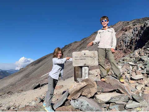
Just a little further along, the trail reaches the edge of Packwood Glacier where a decision awaits: take the stock trail and traverse the glacier OR stay on the ridge line, going up and over the glacier. The up-and-over choice has the bonus of getting you closer to the Old Snowy side-trail. But if you’re scared of heights in any way, the coming down part of the up-and-over is going to be a challenge. And what you come down to is the skinny spine of a mile-or-so long ridge, aptly named The Knife or the Knife’s Edge, special for its slightly unnerving bits, often high winds, and knife-like profile. In places the trail is (or at least seems to be) just a few feet across with steep drop-offs to glaciers either side. At an altitude of ~7000 feet, you get a pretty good panorama of the many surrounding peaks, and – because it’s the Knife – you also get to look down to lakes, rivers, and gorgeous alpine meadows.

Lachlan (7) and Magnus (11) at the decision point: go up to Old Snowy or shoot straight across Packwood Glacier to The Knife. Smoke from a wildfire can be seen in the distance.
We secured our campsite and did the Knife as a day hike. Going north, we chose the stock route across Packwood Glacier to get to the Knife, and I have to say it was pretty hairy in places with melting ice, loose rocks, and a very steep drop off. At the time, I didn’t know it was a stock trail, so it was a pride-deflating moment when a pile of horse dung in my way announced that the trail was probably not as technical as I thought.
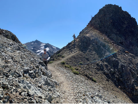
We started along the Knife in blustery wind; lots of loose gravel made down-hill portions a little tricky but otherwise we found it an easy walk. The rock formations seemed straight out of a movie, and with croaking ravens soaring the ridge right alongside you, it can feel like you’re really in Middle Earth. Both kids loved it and there are spots to stop, sit, and drink it all in along the way.

Hiking along the dramatic spine of The Knife.
Wildfires are increasingly typical at the tail end of summer, and we saw a 10-mile wall of smoke with one giant plume to our northeast as we crossed. PCT through-hikers kept asking us if we knew the name of the fire (we didn’t) so they could keep track of its movements as they headed only just slightly to the west of it. This year, many through-hikers had to leapfrog sections of the trail due to the massive Dixie fire, but even just the smoke of wildfires is a big deal for all hikers, with some terrain socked in under purple air (high particulate) for weeks at a time.

Staring up at the face of Old Snowy along its very steep spine from The Knife.
On our southward return across The Knife we got to stare up at the solemn face of Old Snowy – a giant cracking, windswept granite peak standing at just under 8000 feet. From The Knife, the trail up to it looks impassable and you can see more people crossing the stock trail than the alternate up-and-over trail along Old Snowy’s spine. As Mum, the whole thing looked freaking scary. But we started up it anyway and I just kept my head down and focused on the tiny form of Lachlan, my 7-yo daughter, gamely hiking ahead of me. I initially imagined how I would catch her if the wind lifted her, but the near-continuous sound of broken granite tumbling down nearby brought forth a whole new set of imaginings. We reached the top in about 30 minutes, only to discover it wasn’t really the top, and that there was in fact another 600 feet or so of giant loose granite slabs left to climb. The trail got almost imperceptible at some points, and as we huddled under a particularly distressing overhang, I was certain we’d gone the wrong way. But no, this scary-as-hell bit was the ‘trail’ and after a tense stare-off with my husband (I wanted to call it good and he couldn’t believe I would quit so close to the top), we proceeded … UP. I can’t tell you exactly how we got past that bit because I have blocked it from my mind.

Hiking up the spine of Old Snowy, above The Knife and Packwood Glacier, with Rainier in the distance.
The peak is actually quite gratifying because it is a true peak; you can sit on the very top rock. Magnus went up there and did the best wolf howl. No wolf howled back, but it was super windy, and we simply may not have heard. It turns out that some people take their dogs across the Knife and up Old Snowy, so it is clear the most difficult way to do these things is as a Mum with young kids in tow. I applaud myself.

Magnus howling to the wolves at the very top of Old Snowy.
The next morning we packed up camp amid many cute pikas and chipmunks before returning to the Loop Trail and hiking out on a mostly downhill trajectory.

Magnus and Lachlan spotting pikas at our campsite with Adams in the background.

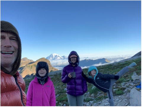
Mornings were freezing but sunny.
I would do this hike again and recommend it for anyone, including young families. There are parts that might unnerve some people (like me) but they are still non-technical. And, the views are incredible.
by Sheridan Porter

Leave a comment